

ENGRAVINGS & PRINTS
Wednesday 23 March 2022 at 14:00
9 rue de Provence, 75009 Paris
400 lots
-
1 - FRONTISPICE OF ATLAS - G. MERCATOR - "ATLAS or Representation of the Universal World and of the parts of it, made in tables and very ample descriptions, Volume Second". 1633. Engraved with etching and burin. Old coloring. Proof on laid paper. Published by H. HONDIUS in 1633, in Amsterdam. Margins. 48 x 28 cm. Condition A .
Estimate €100 - €150 -
2 - MAP OF THE MOON & Space Shuttles, by Jacques DEVOS (1924-1992). c.1968. The map features portraits of Apollo 8 astronauts Frank Borman, James Lovell and William Anders, as well as a portrait of cosmonaut Yuri Gagarin. Published by Le Journal de Spirou in 1968. Folded. 75 x 100 cm. Condition A.
Estimate €180 - €200 -
3 - POSTER - MAP OF THE MOON, 1972. Printed in Germany. Offsetdruck Hermann F.R. Stumme, Hamburg 36. Copyright 1972 by Falck-verlag (Germany). Rolled. 104 x 85 cm. Condition A (small traces of handling on the edges).
Estimate €200 - €250 -
4 - SKY MAPS Extracted from ASTRONOMIE POPULAIRE, Camille Flammarion. 2 maps: 1- "Planisphère Céleste (Hémisphère BOREAL)" & 2- "Planisphère Céleste (Hémisphère Austral)". Maps printed in colors. Folded. About 44 x 63 cm each. Condition A (good condition). Set of 2 pl.
Estimate €180 - €200 -
5 - MAPPEMONDE - Petruccelli - GLOBAL MAP for GLOBAL WAR and Global PEACE, 1943. Copyright Aluminium Company of AMERICA. On the back some information about military aviation. Folded. 60,5 x 85 cm. Condition A (good condition).
Estimate €150 - €200 -
6 - MAPPEMONDE - DE FER, N. - "Introduction to geography, of the correspondence of the terrestrial globe or world map... "Paris, 1705. Double hemisphere by Nicolas DE FER. Printed in 1705 in Paris, at the Author's, in the Isle du Palais on the Quays of the Clock at the Royal Sphere, with privilege of the King. California is detached from the American Continent and forms an island. Engraved map. laid paper. Colored. Verso without text. 51 x 71 cm. Condition A
Estimate €600 - €800 -
7 - MAPPEMONDE - "Mappemonde Divisée en ses 4 Parties". c.1755. Engraved map. Colored. laid paper. 17 x 32 cm at sight. 35 x 51 cm. Condition B (some stains).
Estimate €150 - €200 -
8 - MAPPEMONDE - J. B. POIRSON (1761 - 1831) - "Mappe-monde, divided into two hemispheres Eastern and Western ...", Paris, 1798. By J. B. POIRSON, geographer engineer, Year VI. In 1798, in Paris, at Jean. Engraved by BERLIN. On strong paper. The 5 continents are delimited by different colors. Colors of the time. 75,5 x 53,5 cm. Condition B (Dated paper, creases, stains, soiling and small marginal tears).
Estimate €400 - €800 -
9 - MAPPEMONDE AIR France - "Air France Réseau Aérien Mondial". 1937. Color postcard, designed by Lucien BOUCHER. Printed by Perceval, France. With the network of the company which linked Europe to the Far East, Brazil and Argentina.9,5 x 14,5 cm. Condition A
Estimate €60 - €80 -
10 - PLANISPHERE AIR FRANCE, "On the world's longest network, the most modern aircraft". AIR FRANCE flyer printed in color. 49 x 67 cm. Condition A (good condition).
Estimate €100 - €120 -
11 - PLANISPHERE AIR FRANCE, "On the world's longest network, the most modern aircraft". AIR FRANCE flyer printed in color. 49 x 67 cm. Condition A (good condition).
Estimate €100 - €120 -
12 - MAPS OF EUROPE & FRANCE, 7 MAPS composed and drawn by H. DUFOUR, circa 1860. Maps engraved by Ch. DYONNET. From the book "ATLAS Universel physique, Historique et Politique de Géographie ancienne et moderne. Colored boundaries. 61 x 79 cm approximately each plate. Original folds. Condition A (good general condition).
Estimate €80 - €100 -
13 - MOROCCO - VIEW of "TANGERE (Tangier)". c.1690. Etched and engraved. Proof on laid paper, in old colors, published by Jacques Peeters in Antwerp. Margins. Rare. 16 x 28 cm. Condition A (Margins slightly dusted).
Estimate €100 - €150 -
14 - MOROCCO - "At the Moroccan wizard". Beginning of XX th century. Wood engraved in colors by Georges MARCAIS (1876-1962). Signed with the artist's monogram in the lower left corner of the composition. Proof on laid paper, justified "tiré à 15 ép.(reuves)" and countersigned in pencil by the artist. Margins. 31 x 23,5 cm. Condition A (small traces of sticker on the edge of the right margin, otherwise good condition).
Estimate €100 - €200 -
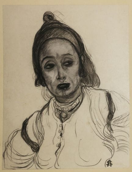
15 - MOROCCO - A. SURÉDA - [WOMAN OF MARRAKECH]. Early 20th century. Sketch on paper by André SUREDA (1872-1930). Signed with the artist's stamp. 20,2 x 15,5 cm for the subject. 30 x 25,5 cm with the support. Condition A (good state of conservation).
Estimate €400 - €600 -
16 - ALGERIA- VIEW of "ORAN e MARSAGUIUR". c.1690. Etched and engraved by Gaspar Bouttats (1640-1695). Proof on laid paper, published by Jacques Peeters in Antwerp. Margins. Rare. 16 x 28 cm. Condition A (Margins slightly dusted).
Estimate €100 - €150 -
17 - ALGERIA - "SPAHIS". XIXth. IMAGERIE of NANCY. Engraved wood. Old colors. Printed on fine paper at Delhalt in Nancy. Margins. 29,5 x 39 cm. Condition A (good condition).
Estimate €100 - €200 -
18 - LIBYA - "LYBIA tourist Map". XX th. 2 illustrated maps printed in color. Folded. 47 x 66,5 cm & 39 x 27 cm. Condition A (good condition).
Estimate €180 - €200 -
19 - EGYPT - ANCIENT PHOTO of the XIXth. "PYRAMIDS OF CHYZEH, General view". 24 x 31,5 cm for the photo. 37,5 x 46 cm for the support. Condition B (light freckles).
Estimate €150 - €200 -
20 - UNITED STATES - NEW YORK - Reunion of 2 TOURIST MAPS. 1- "Map of New York City contents House numbers Guide, Subway, Elevated street cards". Published by Hagstrom's Company. Edition of 1948. 2 maps folded inside (78 x 42 cm approx. each). 2- "Official SOUVENIR MAP New York WORLD'S FAIR 1964/1965", by the Editors of Time-Life Books. Color map, folded. (84 x 64 cm). Condition A. Set of 2p.
Estimate €120 - €150 -
21 - USA - Reunion of 4 COLOR ILLUSTRAL PLANS of NEW YORK, Vintage: 1- "NEW YORK WORLD'S FAIR by subway and automobile", Copyright by HAGSTROM Company Inc. 1939. Plan made for the 1939 New York World's Fair highlighting travel routes to the fair and all that the city has to offer visitors. Folded. 41.5 x 54 cm. Condition A (good condition). 2- "MAP OF NEW YORK Subways, Elevated Lines", 1946, published by Hagstrom Company. Folded. 86 x 48 cm. Condition A (good condition). 3- "MAP of New York, Theatres
Estimate €300 - €400 -
22 - UNITED STATES - NEW YORK - 18th century OPTICAL VIEW - "VIEW of NEW YORCK, a City situated in Northern AMERICA in the Isle of MANAHATAN near the Mouth of the HUDSON River []". Engraving in old colors. laid paper. In Paris, at J. Chereau rue St Jacques above the Fountain St Séverin aux 2 colonnes n°257. Margins. 30 x 43,5 cm. Condition A (a tiny little hole in the sky, otherwise good condition).
Estimate €150 - €300 -
23 - UNITED STATES - NEW YORK - 18th OPTICAL VIEW - "The Destruction of the Royal STATUE in NEW YORK" & on the reverse "4th New Optical View, representing the Church and the Professed House of the Jesuits in Augsburg erected in honor of the Holy Virgin, by Rudolf the Fourth in 1360". 2 Engravings in old colors formerly glued back to back. 30,5 x 39 cm. Condition B/C (cut to the subject, some traces of handling and slightly dusty).
Estimate €150 - €300 -
24 - UNITED STATES - MASSACHUSETTS - TRAVEL MAP. "A World of Fun and Relaxation - Massachusetts - The Historic Vacationland, a Travel Map to help you feel at home in the Bay State!", Ernest Dudley. c.1965. Color printed and illustrated map after E. Dudley depicting historical landmarks, churches, sports, bridges, monuments, schools and historical facts such as Bell's Invention of the telephone... (but also PLYMOUTH ROCK; Bunker Hill Monument Charlestown, Springfield Armory, Boston Museum of Fine Arts
Estimate €100 - €150 -
25 - UNITED STATES / USA - BOSTON - "VIEW from the Grand Street to the South Church of the Presbyterians in BOSTON". 18th century. OPTICAL VIEW. Engraving by François X. Habermann (1721-1796). Older colors. laid paper. With the address "Se vend à Augsbourg au Negoce commun de l'Académie Impériale d'Empire des Arts Libéraux avec Privilège de Sa Majesté Impériale et avec Defense ni d'en faire ni de vendre les copies". Small margins. 35,2 x 44 cm. Condition B/C (slight trace of wetness on the ri
Estimate €150 - €300 -
26 - UNITED STATES / USA - BOSTON - "VIEW of the Street and Town House in BOSTON". 18th century. OPTICAL VIEW. Engraving by François X. Habermann (1721-1796). Antique colors. Layered paper. With the address "Se vend à Augsbourg au Negoce commun de l'Académie Impériale d'Empire des Arts Libéraux avec Privilège de Sa Majesté Impériale et avec Defense ni d'en faire ni de vendre les copies". Margins. 36,5 x 45,5 cm. Condition B (slight trace of wetness on the right, rare short tears in the margin
Estimate €150 - €300 -
27 - USA - NEW MEXICO - "Historical Trails through NEW MEXICO / The land of enchantment". 1956. Nice illustrated map after STEDMAN and printed in color. Text in English on the back. Folded. 55 x 43 cm. Condition A (good condition).
Estimate €120 - €150 -
28 - CANADA - QUEBEC - "VIEW of the lower city in QUEBEC towards the ST LAURENT river". 18th century. OPTICAL VIEW. Engraving by François X. Habermann (1721-1796). Older colors. Layered paper. With the address "Se vend à Augsbourg au Negoce commun de l'Académie Impériale d'Empire des Arts Libéraux avec Privilège de Sa Majesté Impériale et avec Defense ni d'en faire ni de vendre les copies". Margins. 36 x 43,7 cm. Condition B (two short marginal tears, two pinholes in left margin and rare stai
Estimate €150 - €300 -
29 - CANADA - QUEBEC - "VIEW of the upper town in QUEBEC with the Place to go to ride the Mill". 18th century. OPTICAL VIEW. Engraving by François X. Habermann (1721-1796). Older colors. laid paper. With the address "Se vend à Augsbourg au Negoce commun de l'Académie Impériale d'Empire des Arts Libéraux avec Privilège de Sa Majesté Impériale et avec Defense ni d'en faire ni de vendre les copies". Margins. 35,5 x 44,2 cm. Condition B/C (trace of wetness on the right).
Estimate €150 - €300 -
30 - CANADA - QUEBEC - "VIEW of the Rue des Recolets in the Upper Town of Quebec". 18th century. OPTICAL VIEW. Engraving by François X. Habermann (1721-1796). Older colors. Layered paper. With the address "Se vend à Augsbourg au Negoce commun de l'Académie Impériale d'Empire des Arts Libéraux avec Privilège de Sa Majesté Impériale et avec Defense ni d'en faire ni de vendre les copies". Margins. 35,7 x 44,8 cm. Condition B/C (trace of wetness on the right).
Estimate €150 - €300 -
31 - MEXICO - JANSSON J. - MAP of "NOVA HISPANIA and NOVA GALICIA". 17th century. Engraved map. Colored. Layered paper. Spanish text on reverse. Nice title cartouche at upper right. Map of the western part of Mexico, showing Mexico City and Guadalajara with a large title cartouche with the Spanish royal arms. Folded. Margins. 50.5 x 60 cm. Condition B (some rare foxing but mostly in the margins and lightly sunned).
Estimate €300 - €500 -
32 - URUGUAY - VIEW of "MONTEVIDEO, General View from the Harbor". c.1850. Original lithograph by Adolphe D'HASTREL (1805-1874). Printed in colors on cream wove paper. Printed by Auguste Bry and published by Gihaut Frères, in Paris. Good margins. 38,5 x 52 cm. Condition A (edges of the margins slightly insolated).
Estimate €150 - €300 -
33 - ARGENTINA - VIEW of "BUENOS-AYRES (Buenos Aires), general view taken from the large harbor". c.1850. Lithograph by SABATIER, after Adolphe D'HASTREL (1805-1874). Printed in colors on cream wove paper. Printed by Auguste Bry and published by Gihaut Frères, in Paris. Good margins. 38,5 x 52 cm. Condition A (some stains on the back).
Estimate €150 - €300 -
34 - PANTAGONIA - FIRELAND - James COOK "Map of the southern extremity of America, 1775" from the voyage of James COOK. Engraved on copper by Benard. 43 x 50 cm. Condition A (Some foxing and wetness).
Estimate €150 - €300 -
35 - BRAZIL - "Female of the Brazilian Grigri (Aracaris, commonly known as TOUCAN). c.1773. Engraving by F.N. Martinet, in old colors. Proof on blue laid paper. Margins. 28,3 x 23 cm. Condition C (rare small worm holes and trace of wetness in the left margin reaching a little the edge of the subject).
Estimate €100 - €200 -
36 - GUYANA - ST PIERRE et MIQUELON - MAP OF "French Colonies (in America): French GUYANA, ST MARTIN ISLANDS & St Pierre and Miquelon Islands", by Victor LEVASSEUR, Atlas National de la France illustrée, 1852. Engraved map. Antique coloring. Printed by Lemercier and published by Pelissier, in Paris. Margins. Nice illustrated map. 36,5 x 52 cm. Condition A (good condition).
Estimate €100 - €150 -
37 - CUBA - BARACOA - "VISTA general de la Ciudade y Montanas de BARACOA (Costa del norte)". c.1855. Original lithograph by Frederic Mialhe (1810-1881), printed in colors, on wove paper. Margins. 23 x 30 cm. Condition A (some marginal foxing, otherwise good condition).
Estimate €80 - €100 -
38 - CUBA - TOBACCO - "VISTA de una vega de TABACO (View of a TOBACCO PLANTATION)". c.1855. Original lithograph by Frederic Mialhe (1810-1881), printed in colors, on wove paper. Margins. 23 x 30 cm. Condition A (some marginal foxing, otherwise good condition).
Estimate €100 - €150 -
39 - CUBA - LA HAVANE - "HABANA, 3era VISTA tomada desde CASA BLANCA (view taken from CASABLANCA)". c.1855. Original lithograph by Frederic Mialhe (1810-1881), printed in colors, on wove paper. Margins. 23 x 30 cm. Condition A (some rare marginal foxing and one in the sky).
Estimate €100 - €150 -
40 - CUBA - LA HAVANE- "VISTA de LA HABANA Tomada desde la entrada del puerto". c.1855. Original lithograph by Frederic Mialhe (1810-1881), printed in colors, on wove paper. Margins. 23 x 30 cm. Condition A (some marginal foxing and trace of wetness in the lower margin).
Estimate €100 - €150 -
41 - CUBA - LA HAVANE- "HABANA 2nda VISTA tomada desde CASA BLANCA (2nd View taken from CASABLANCA)". c.1855. Original lithograph by Frederic Mialhe (1810-1881), printed in colors, on wove paper. Margins. 23 x 30 cm. Condition A (rare foxing or stains mainly in the margins).
Estimate €80 - €100 -
42 - MARTINIQUE - MARINE - DEQUEVAUVILLER, F. - "Combat naval, delivered on December 18, 1779 by the COUNT of the MOTTE-PIQUET, chief of squadron", 1779. Etching after ROSSEL, by François-Nicolas Barthélémy DEQUEVAUVILLER. Vellum paper. In Paris, at BANCE Editeur, rue St Denis, n°214. 57 x 77,5 cm. Condition A (In good general condition).
Estimate €300 - €400 -
43 - MARTINIQUE- MAP OF "THE FRENCH COLONIES (MARTINIQUE, SOUTH AMERICA)", by Victor LEVASSEUR, Atlas National de la France illustrée, 1852. Map engraved by Laguillermie. Colored. Printed by Lemercier and published by Combette, in Paris. Margins. Nice illustrated map. 34 x 49 cm. Condition A (good condition).
Estimate €100 - €150 -
44 - GUADELOUPE - MAP OF "French Colonies (in America) [GUADELOUPE]", by Victor LEVASSEUR, Atlas National de la France illustrée, 1852. Map engraved by Laguillermie. Colored. Printed by Lemercier and published by Combette in Paris. Margins. Nice illustrated map. 32 x 47 cm. Condition A (slight insolation in lower margin, good condition).
Estimate €100 - €150 -
45 - LA REUNION- MAP OF "THE ISLAND OF REUNION, French Colony (Indian Ocean)", by Victor LEVASSEUR (Atlas National de la France illustrée), 1852. Engraved map. Older colors. Printed by Lemercier and published by Pelissier, in Paris. Margins. With attributes of the island, PORTRAITS by PARNY & BERTIN to illustrate the map. 36,5 x 52 cm. Condition A (edge of margins slightly insolated, good condition).
Estimate €100 - €150 -
46 - LA REUNION - MUSIC PARTY - "LE SÉGA, Quadrille créole by F.A", 1883. In-4. 4pp. illustrated after A. ROUSSIN and published by "L'Album de la Réunion". 32,5 x 25 cm. Condition B (some foxing and insolate).
Estimate €200 - €300 -
47 - LA REUNION - 2 VIEWS: "Departure from the RIVIERE D'ABORD" & "Site of the edges of the Etang de ST PAUL, near the BERNICA". 1804. 2 plates engraved by Fortier & Adam after drawings by BORY DE ST VINCENT. Proofs on laid paper. From the book "Voyage dans les quatre principales Îles des MERS D'AFRIQUE, fait par ordre du Gouvernement, pendant les années neuf et dix de la République (1801 et 1802) [...]", in Paris, by F. Buisson. Margins. 26,5 x 35 cm each approximately. Condition B (mostly margin
Estimate €150 - €200 -
48 - LA REUNION - VOLCAN - 2 plates: "Second view of the DOLOMIEU Crater" & "VIEW of Ascension at six leagues at sea / View of St. Helena at ten leagues at sea / View of Bourbon Island, in the night of 14 frimaire year X". 1804. 2 plates engraved by Adam and Paris after drawings by BORY DE ST VINCENT. Proofs on laid paper. From the book "Voyage dans les quatre principales Îles des MERS D'AFRIQUE, fait par ordre du Gouvernement, pendant les années neuf et dix de la République (1801 et 1802) [...]",
Estimate €150 - €200 -
49 - LA REUNION - 2 PLATES: "Diverses dispositions des Laves basaltiques dans la RIVIERE DE ST DENIS" & "Le GROS-MORNE; le Brûlé de St Paul; le MORNE DE FOURCHE et CIMANDEF, pris de la PLAINE DES CHICOTS". 1804. 2 plates engraved by Fortier & Adam after drawings by BORY DE ST VINCENT. Proofs on laid paper. From the book "Voyage dans les quatre principales Îles des MERS D'AFRIQUE, fait par ordre du Gouvernement, pendant les années neuf et dix de la République (1801 et 1802) [...]", in Paris, by F
Estimate €200 - €250 -
50 - LA REUNION - 2 PLATES: "View of the MORNE du Bras PANON, taken from the Rivière du Mât" & "View of the encasement of the RIVIERE DE L'EST, taken from the Montée de la R. Sèche". 1804. 2 plates engraved by Fortier & Adam after drawings by BORY DE ST VINCENT. Proofs on laid paper. From the book "Voyage dans les quatre principales Îles des MERS D'AFRIQUE, fait par ordre du Gouvernement, pendant les années neuf et dix de la République (1801 et 1802) [...]", in Paris, by F. Buisson. Margins. 3
Estimate €200 - €250




About the sale
Selling expenses : 28 % TTC in voluntary
Internet fees :
+1.5% ex VAT of the hammer price (i.e. +1.8% incl. VAT) for voluntary lots.
Terms of sale
Show the terms of sale
Frais de vente : 28 % TTC en volontaire
Frais internet :
+1.5% HT du prix d'adjudication (soit +1.8% TTC) pour les lots volontaires.