
Lot n° 7
Estimation :
200 - 300
EUR
SAINT-PIERRE-ET-MIQUELON (97) - MAP - XVIIIth... - Lot 7 - Eric Caudron
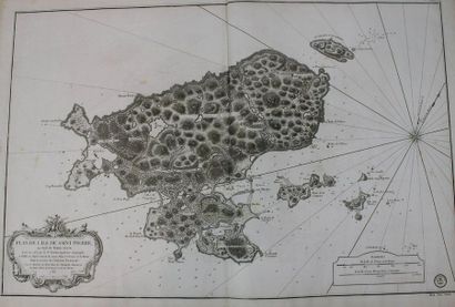
SAINT-PIERRE-ET-MIQUELON (97) - MAP - XVIIIth c. "PLAN DE L'ILE DE SAINT-PIERRE, au Sud de Terre-Neuve". 1763. Etching. Nautical chart drawn by the geographer Jean-Baptise FORTIN (1740 † 1817), "for the service of French ships, under the Ministry of M; the Duke of Choiseul". Proof on laid paper. 64.5 x 94 cm (sheet). Usual central median fold. Condition A (handling folds, a few freckles).
My orders
Sale information
Sales conditions
Return to catalogue